
New discoveries #1
Earthformer, Waterbird monitoring & the Satellite cloud generator

Welcome to the very first of my newsletters on the topic of deep learning applied to satellite and aerial imagery 🛰️
Earthformer
I was interested to see the publication earthformer-exploring-space-time-transformers-for-earth-system-forecasting from Amazon science, since it is not among the usual topics that I discover material on. The researchers demonstrate state-of-the-art performance on precipitation nowcasting and El Niño/Southern Oscillation (ENSO) forecasting. The Earthformer network derives its name from the Transformer architecture which it uses. The authors note several limitations of the Earthformer, including blurry predictions with a lack of small scale features, and that the model does not take advantage of the physical knowledge of the Earth system. Nevertheless I think the potential of using deep learning in forecasting is significant 🌍
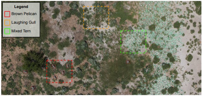
Waterbird monitoring using aerial imagery
In this paper Detectron2 (an open source deep learning platform from Facebook) is used to detect 16 classes of waterbird species that are commonly found in colonial nesting islands along the Texas coast. The authors report that this is one of the largest number of species detected by a single model for UAV-based waterbird monitoring research. I think this is a good demonstration of how meaningful research can be performed without being a pytorch ninja 🥷
Competition: Precision in Building Segmentation
This is an ongoing competition run by The Norwegian Mapping Authority. There are two different tasks to segment buildings, where the first task can only utilize aerial images, while the second must use laser data (LiDAR) with or without aerial images.
💰 Cash prizes are available
📅 Make your submission by the 25th of November
Satellite cloud generator video
🎥 Mikolaj and I did a video on his cloud generator project on Github