
New discoveries #14
PaRK-Detect, LSKNet, Sat2Density, OnlyPlanes Dataset, Pools and WaterTanks datasets

Welcome to the 14th edition of the newsletter. I'm delighted to share that the newsletter now has 4,384 subscribers 🔥
PaRK-Detect

Keypoint detection has been successful in human pose estimation and facial landmark detection but is under-utilised in remote sensing. Patch-wise Road Keypoints Detection (PaRK-Detect) is a new method for road extraction from satellite imagery that addresses the limitations of existing approaches.
Pixel-wise semantic segmentation can produce road graphs with low connectivity, and graph-based methods are computationally expensive and focus on local information. In contrast, PaRK-Detect predicts the position of patch-wise road keypoints and their relationships to construct road graphs efficiently in a single pass. It also performs pixel-wise semantic segmentation and generates road segmentation masks.
PaRK-Detect achieves competitive metrics on benchmark datasets and significantly improves inference speed.
LSKNet: Large Selective Kernel Network for Remote Sensing Object Detection

Recent research on remote sensing object detection has been focused on improving the representation of oriented bounding boxes, but has overlooked the prior knowledge unique to remote sensing scenarios. Such prior knowledge can be useful because tiny remote sensing objects may be mistakenly detected without referencing a sufficiently long-range context, and the long-range context required by different types of objects can vary.
In this paper, a new approach called Large Selective Kernel Network (LSKNet) is proposed which can dynamically adjust its spatial receptive field to better model the ranging context of various objects in remote sensing scenarios. LSKNet has set new state-of-the-art scores on standard benchmarks, and a model similar to LSKNet ranked second in the 2022 Greater Bay Area International Algorithm Competition.
This technique has the potential to improve the accuracy of remote sensing object detection.
Sat2Density: Faithful Density Learning from Satellite-Ground Image Pairs

This paper presents a method called Sat2Density to learn accurate 3D representation of a satellite scene from 2D data (pairs of satellite and ground images). Sat2Density addresses challenges such as absence of sky from the satellite view and changes in illumination between the ground image and satellite sample. The model is trained with 256 × 256 satellite images and outputs a 256 × 256 × 65 implicit volume density and a 128 × 512 360° panorama image.
Unlike past techniques (which require extra 3D information during training), Sat2Density can automatically learn 3D geometry from 2D-only supervision. The learned 3D density allows the generation of spatial and temporal ground videos from satellite imagery.
Improved understanding of 3D geometry from 2D satellite images can lead to a variety of applications where a more detailed perspective on the distribution of objects in space is required, and by relying on existing 2D imagery, there is no cost increase on the acquisition side of the pipeline.
OnlyPlanes Dataset

OnlyPlanes is a synthetic satellite image training dataset of airplanes in a top-view that contains 12,500 images, 132,967 aircraft instances, with 80 fine grain attributes. Pretrained Faster-RCNN and a Mask-RCNN models are also released
Pools and WaterTanks datasets
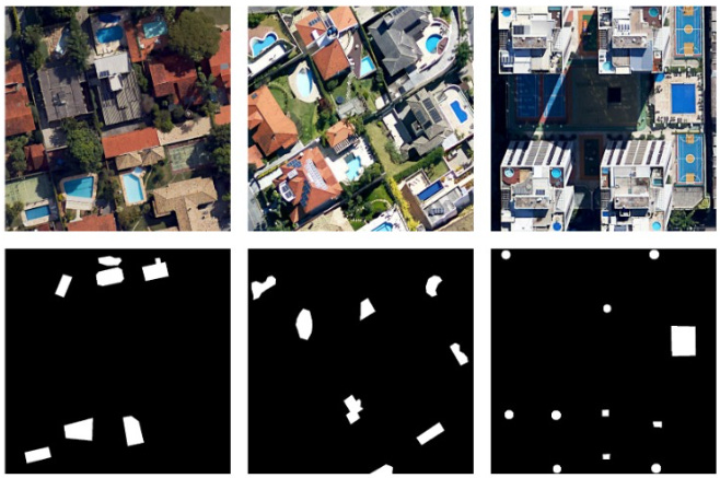
The BH-Pools and BH-WaterTanks datasets are with annotated swimming pools and water tanks respectively. Both datasets consist of imagery from several neighbourhoods in the city of Belo Horizonte, Minas Gerais, Brazil. These datasets and several more are produced by the Pattern Recognition and Earth Observation Lab (PATREO). I discovered this dataset whilst working through a getting started with DVC (Data Version Control) guide
Discord update 🗣️
The Satellite Image Deep Learning Discord server provides a free-to-join chat platform similar to Slack. I am excited to share that the server now boasts 340 members, with activity levels consistently on the rise. Lately, there have been numerous engaging posts, encompassing not only machine learning but also a diverse array of remote sensing topics. I hope to see you there!
Poll
In the previous poll, 50% of respondents cited low code quality as the reason for not regularly publishing code with their papers. Code quality includes factors like readability, efficiency, scalability, and adherence to standards. To improve code quality, tools such as code formatters and AI-powered documentation and testing tools can be used. Github Copilot is one such tool that has been helpful to me personally. In this new poll, I'm curious about the extent to which AI tools like this are being used in the remote sensing community.