
New discoveries #12
Sub-continental-scale mapping of individual trees, Label-conditional Synthetic Satellite Imagery, Roofline-Extraction dataset, Detecting ships in port competition & two new videos

Welcome to the 12th edition of the newsletter. I'm delighted to announce that the number of subscribers has continued to grow, and the newsletter now has 3.7k subscribers 🎉
Sub-continental-scale mapping of individual trees

Accurate information on dryland tree distribution and carbon content at sub-continental to continental scales is crucial for ecological protection, carbon accounting, and climate mitigation. The study "Sub-continental-scale carbon stocks of individual trees in African drylands" in Nature demonstrates the use of machine learning to locate over 9.9 billion trees across sub-Saharan Africa, an area equivalent to the continental United States plus Alaska. Previous models had underestimated the carbon stocks of scattered trees in this area due to the use of coarser spatial data. The study's success was due to the use of high-resolution satellite images and careful dataset curation to account for variation in spectral bands, atmospheric conditions, and sun-target-satellite angles. The authors highlight the importance of accounting for all sources of variation within the training dataset for successful machine learning. This paper showcases how simple machine learning techniques can have a significant impact when combined with careful dataset curation.
📖 Paper
💻 Code
🗺️ Data viewer
Label-conditional Synthetic Satellite Imagery
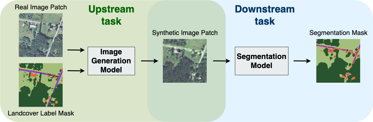
The paper “Mask Conditional Synthetic Satellite Imagery” introduces a model for generating synthetic satellite imagery datasets by utilising a mixture of real high-resolution images and accompanying land cover masks. The authors find that incorporating a mixture of real and synthetic imagery during the training of ML models acts as a data augmentation method, producing better models than those trained solely with real imagery. For those interested in exploring synthetic imagery generation further, Mikolaj has developed a new course titled "DiffusionFastForward" on Github and YouTube
Dataset: Roofline-Extraction

The repository below contains the dataset for the paper “2D Image-To-3D Model: Knowledge-Based 3D Building Reconstruction (3DBR) Using Single Aerial Images and Convolutional Neural Networks (CNNs)”. Note that the same author released a dataset of roof types 🏠
Competition: Detecting ships in port

The goal of this competition is to use satellite imagery to detect ships in ports. The resulting algorithm will allow port managers to better allocate port resources for incoming and outgoing vessels, and make more informed decisions to manage and optimise the logistics.
📆 Private leaderboard will be revealed on 16 April 2023
🖥️ Webpage
🤗 Prizes include Jetson Nano and Huggingface swag
New video: Satellite image time series with Gilberto Camara
In this video, I caught up with Gilberto Camara to talk about SITS. SITS is an open-source R package for land use and land cover classification of big Earth observation data using satellite image time series. Gilberto is a Senior Researcher in GIScience, Geoinformatics, Spatial Data Science and Land Use Change at Brazil’s National Institute for Space Research. *
New video: MAFAT object detection challenge with Shai Schneider
In this video, I caught up with Shai Schneider to discuss the MAFAT challenge series, including his experience running the two most recent challenges. The goal is to train oriented object detection models that can identify objects from various classes - such as airplanes, vehicles & vessels. Read about the MAFAT challenge in Newsletter #9
Poll
In the previous poll, I asked researchers why they don't regularly publish code with their papers. 50% of respondents cited low code quality and 25% cited a lack of time as reasons. This suggests that academics often don't have the time or motivation to refine and document their code for release, which is understandable given the pressures they face. However, it also implies that academics may not be fully prepared to contribute to a commercial setting where code quality and documentation are crucial. One way to gain experience in working on production-level code is through contributing to open-source projects. Personally, I found this to be an effective way to gain experience. In this poll, I am interested in gauging the level of activity in open-source projects.