
New discoveries #11
Turkey Building Damage Assessment, SegForestNet, Real-time tracking of wildfire boundaries and Raster Vision with Adeel Hassan

Welcome to the 11th edition of the newsletter! I'm thrilled to announce that the subscriber base continues to grow and now stands at over 3.3k subscribers.
Comment on the Turkey/Syria Earthquake response
As many of you may be aware, on February 6th a devastating earthquake struck Turkey and Syria, and many in our community quickly mobilised to provide critical imagery and mapping support to aid emergency responders on the ground. In particular, having a map of the affected buildings is of great value, and people from all over the community rallied to create maps of damaged buildings using both traditional annotation and deep learning approaches.
However, I observed that several teams were pursuing their own efforts to generate these maps with little coordination, which resulted in duplicated efforts. To address this issue and help promote more efficient and collaborative efforts, I created a dedicated channel on the satellite-image-deep-learning Discord server called "building-detection". I am thrilled to report that this channel has already had a positive impact by increasing collaboration and knowledge sharing between these teams. I hope that the Discord server will continue to be a valuable focal point for our community, and I encourage everyone to join and participate in these important efforts.
Turkey Building Damage Assessment
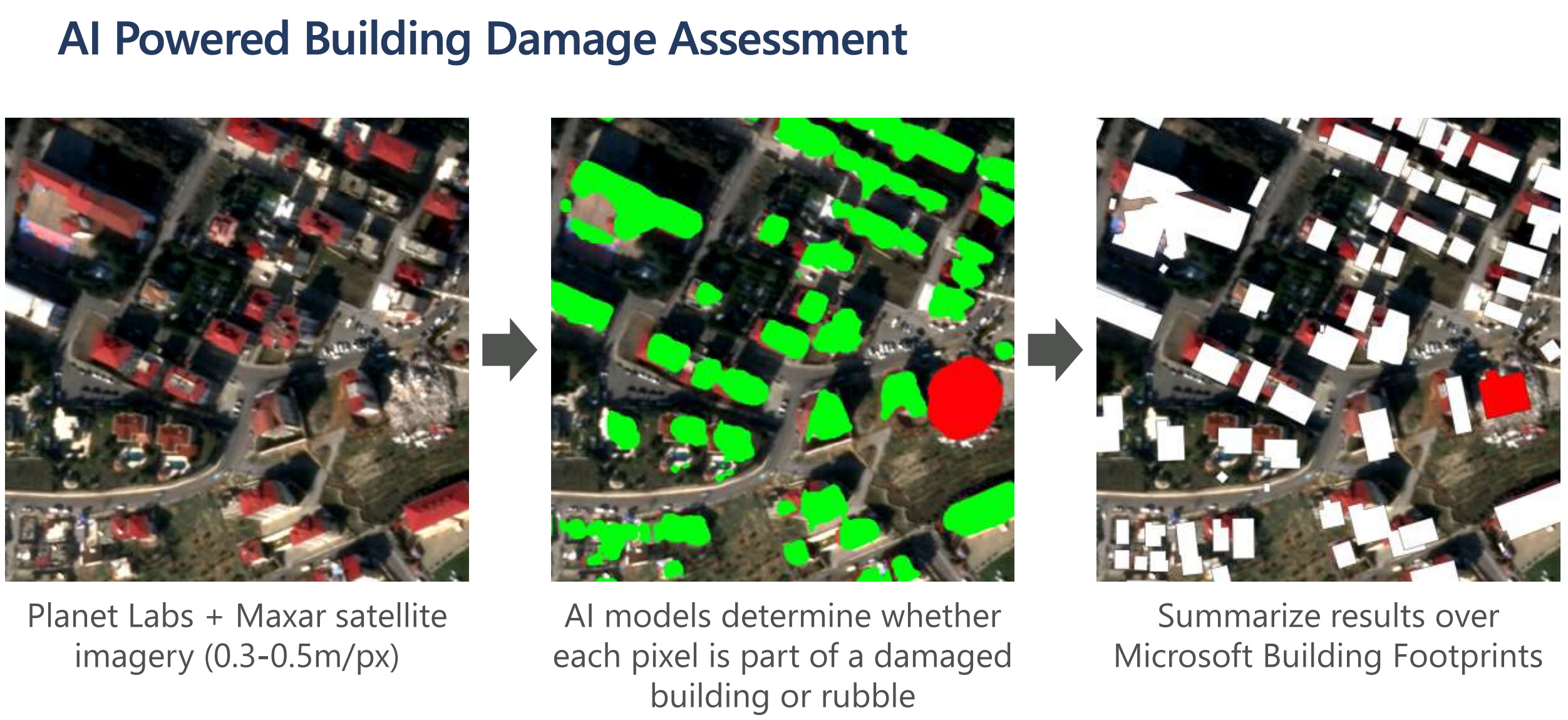
A team of researchers from Microsoft AI for Good, the Defence Innovation Unit (DIU), and Berkeley AI Research, using high-resolution satellite imagery from Planet and Maxar, have produced an initial assessment of the damage caused by the recent earthquake in Turkey. The team utilised a deep learning segmentation model to detect damaged buildings in four cities, with a model that was pre-trained on data from the Xview2 competition and fine-tuned on imagery from Turkey. Their rapid assessment identified the most impacted city and revealed a total of 3,849 damaged or destroyed buildings across all four cities. Moreover, the team estimated that 160,000 people live in or immediately adjacent to these damaged buildings. Please refer to the press release below for more information on this work, which was turned around in a very short timeframe. I look forward to seeing more innovative and impactful work in this space, as deep learning continues to play an increasingly important role in supporting emergency response efforts.
SegForestNet

The typical method for detecting structures in aerial images involves using deep learning models for semantic segmentation, which can result in fuzzy predictions at the edges of objects and require post-processing to convert the predictions to polygon shapes. The paper SegForestNet: Spatial-Partitioning-Based Aerial Image Segmentation presents a new approach, called SegForestNet, which uses binary space partitioning (BSP) trees to simplify the prediction process and produce more accurate results. BSP trees are an efficient representation of objects in aerial images and allow for a limited number of polygon shapes in the predictions, streamlining the process. The new model incorporates a range of modifications to an earlier model (BSPSegNet), including a new feature decoder architecture and a new differentiable BSP tree renderer to avoid vanishing gradients, as well as a novel loss function designed to improve the spatial partitioning defined by the predicted trees. Compared to state-of-the-art methods, SegForestNet achieves better performance on benchmark datasets (Potsdam, iSAID, etc.) while using fewer model parameters. This is a promising direction for aerial image segmentation, as smaller model sizes can bring significant practical benefits. However, it should be noted that the classic Unet model remains competitive. Overall, the SegForestNet approach presents promising method for detecting structures in aerial images, which will have a range of important applications in fields such as geospatial analysis and environmental monitoring.
Real-time tracking of wildfire boundaries

The article "Real-time tracking of wildfire boundaries using satellite imagery" from Google's AI blog announces a cutting-edge system for monitoring and tracking wildfires in real-time in the US, Mexico, most of Canada and Australia. It offers improved accuracy compared to existing solutions and provides critical information to first responders. The system leverages data from multiple geostationary satellites to achieve a balance between spatial resolution and update frequency. It utilises a Convolutional Neural Network (CNN) deep learning model trained on RGB + IR imagery, which allows it to learn the relative importance of different bands. The model receives a sequence of the three most recent images from each band so as to compensate for temporary obstructions such as cloud cover. The model receives inputs from two geostationary satellites, resulting in a super-resolution effect that improves detection accuracy beyond the pixel size of either satellite. The system is designed to provide real-time information on the location and spread of wildfires, with updates available every 10-15 minutes. It also generates alerts to notify first responders when a new fire is detected, enabling a more rapid response and minimising damage to communities and the environment. Google plans to expand the service to more countries and continue working to help fire authorities access critical information in real time.
🖥️ Blog post
Video: Raster Vision with Adeel Hassan
In this video, I caught up with Adeel Hassan to learn about Raster Vision. Raster Vision is an open source library and framework that bridges the divide between the world of GIS and deep learning-based computer vision. It provides a configurable computer vision pipeline that works on chip classification, semantic segmentation, and object detection.
🖥️ Raster Vision docs: https://rastervision.io/
Discord update 🗣️

In the 9th edition of this newsletter, I announced the launch of the satellite-image-deep-learning Discord server, a free-to-join chat platform similar to Slack. I am delighted to report that we now have over 200 people on the server, and I am thrilled to see so many of you engaging in the discussions and sharing knowledge. Discord offers many exciting features, including the ability to host live meetups and present to the community. With this in mind, I am excited to announce a community meetup scheduled for Friday, February 17th, at 14:30 GMT on the Stage voice channel. During the event, I will provide a brief summary of the contents of this newsletter, followed by a Q&A session to address any questions you may have. We can then move on to discuss any topics of interest to those in attendance. I believe this will be an excellent opportunity to connect with the community and discuss the latest developments in the field. I hope to see you there!
Poll
In the last poll, I asked the question: "How important is it to have code published alongside the paper?" The overwhelming majority of respondents (74%) said that code is important. In newsletter #10, I estimated that less than 5% of papers are published with code, highlighting a significant gap between expectation and reality. In this poll, I want to delve deeper into this issue by exploring why the number of papers published with code is so low. By understanding the underlying reasons, I hope we can work towards improving the publication of code alongside research papers, thereby increasing transparency and reproducibility in the field.
Thank you for your contributions.
I loved the new Jobs section. It will be very helpful for the community! Thanks for your efforts and well done job, Robin! :)